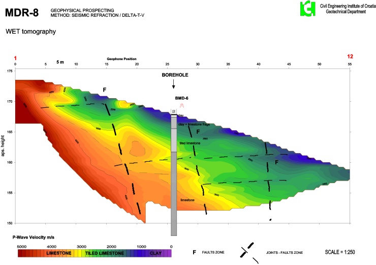
Our Rayfract® refraction tomography software allows reliable imaging of subsurface velocity structure including
faults, strong lateral
velocity variation and other velocity anomalies.
Our Smooth inversion tomographic method is based on physically
realistic modeling of first break propagation for P-wave and S-wave surveys. We forward model
refraction, transmission and diffraction (Lecomte, 2000) and
back-project traveltime residuals along wave paths also known as
Fresnel volumes (Watanabe, 1999) instead of conventional rays. This
increases the numerical robustness of the inversion. A smooth minimum-structure and artefact-free 1D starting model is
determined automatically directly from the seismic traveltime data by
horizontally averaging DeltatV (Wiechert-Herglotz) method
1D velocity-depth profiles along the seismic line. The starting model is then refined with 2D
WET Wavepath Eikonal Traveltime inversion (Schuster, 1993).
No need to map traveltimes to refractors.
Plot 1.5D refractors obtained with layer-based
Plus-Minus and
Wavefront refraction methods on 2D WET tomograms.
Map traveltimes to refractors interactively or semi-automatically.
Automatically convert mapped refractors to
layered starting model for WET inversion.
Smooth inversion of borehole surveys with constant-velocity starting model for
crosshole,
zero-offset VSP,
walkaway VSP,
reverse VSP and
VSP constrained refraction surveys.
Image Poisson's ratio via P-wave and S-wave refraction surveys.
Bidirectional frequency filtering of traces with single-pole or Chebyshev-Butterworth filter.
Check your picks for reciprocal traveltime errors
in Trace|Offset gather display. Shift picks for all traces of same shot with trigger delay correction.
Work through our SAGEEP 2010 short course manual
(PowerPoint version,
function key help).
Import SEGY and SEG-2 seismic data files and
3rd-party ASCII files using
.HDR batch import of shots. Our
XTV inversion models
critical refraction of first breaks (intercept-time method) besides
diving waves (with
DeltatV method) and allows better
modeling of low-velocity weathering overburden without a gradient, now both for
1D starting model and for
pseudo-2D imaging.
Use Gaussian smoothing as an alternative to uniform smoothing during WET inversion for better resolution.
We now support the
Conjugate Gradient method
for improved
imaging of sharp velocity contrasts
besides our default Steepest Descent method.
Use your layered refraction starting model
for WET inversion. Our latest version 4.06 allows
display of your reciprocal first break picks on Shot gather trace display for easier quality control.
Improve tomogram resolution with multiscale tomography using our multirun WET inversion.
Weight WET velocity update across wavepath with Cosine-Squared function instead of Gaussian function for improved
imaging of vertical fault zones
. Version 4.06 supports Wavelength-Dependent Velocity Smoothing
(Zelt and Chen 2016)
for
sharper imaging of layer boundaries, better resolution in overburden and
tunnel detection.
We can process first breaks recorded with a
circular receiver spread planted on tunnel wall. Visit our booth #12 at
SAGEEP 2024
in Tucson AZ U.S.A.
Modeling
Functionality
Details
Licensing
Order
Contact
Brochure
Release Notes
Old Release Notes
Reseller
Trial
Install
Manual
Short Manual
Help
latest DeltatV help
DeltatV Theory
latest XTV help
XTV Theory
Short Course
Tutorials
Old Tutorials
Get started with tutorials
Clients
Lay Terms
Canadian Trademark
Swiss Trademark
Updated Surfer scripts for version 4.01 & Surfer 18/19/20/21
Run 4.03 base installer
WibuKey 6.51 runtime installer for Windows 7 to 11 64-bit Pro
WibuKey 5.20b runtime installer for 32-bit Windows XP
Update WibuKey runtime
CodeMeter 6.90 runtime installer for Windows 7 64-bit Pro
CodeMeter 7.30a runtime installer for macOS 10.13 High Sierra
Install CodeMeter runtime
Generate license request
Import license update
Configure CodeMeter server and clients
Ad in GSA Today
Latest 2024 ad
Olson Engineering refraction webinar
 View these tutorials, application samples and theoretical publications :
Blind test of methods for obtaining 2D near-surface seismic velocity models
from first-arrival traveltimes (Zelt et al. JEEG, September 2013, Volume 18, Issue 3, pp. 183-194)
Frequency-dependent traveltime tomography for near-surface seismic refraction data (Zelt and Chen, Geophys. J. Int 2016)
Application of geophysical techniques to support geological mapping projects
(Benjumea et al. EAGE First Break Aug 2016)
Multi-Source Data Integration to Investigate a Deep-Seated Landslide Affecting a Bridge
(Pastor et al. Remote Sensing 2019)
Seismic Refraction Survey for Bedrock Investigation
(Advanced Geoscience Inc. 2020)
Prospezione geofisica multi-parametrica per la caratterizzazione di un'area in frana
(Diego Barbero and Mario Naldi, Convegno Nazionale di Geofisica della Terra Solida GNGTS Bologna, Italy 2018)
Import SEG-2 shots into borehole profile database, update header data, Smooth invert with WDVS smoothing (GHD data)
Geomechanical parameters assessment and geological characterization using fuzzy c means clustering of electrical resistivity and seismic data
(Benjumea et al. EAGE NSG Jan 2023)
Geophysical characterization of the shallow subsurface in sites P2 and P3 from high-resolution active-source seismic profiling and downhole data
(Villani et al. Istituto Nazionale di Geofisica e Vulcanologia 2022)
A Preliminary Investigation into the Water Sources of Iron Fens in Mineral Creek Basin, San Juan County, Colorado
(Basin Hydrology, Inc. 2017)
Investigation of fractured rock beneath a uranium-tailing storage dam through UAV digital photogrammetry and seismic refraction tomography
(Guireli Netto et al. Front. Earth Sci. Dec 2023)
Fucino Basin structure revealed by the tomography and the reusing of the CROP11 seismic data
(Caielli et al. Tectonophysics Volume 865, 20 October 2023)
Multiscale Conjugate-Gradient WET+WDVS using using fail-safe 1D-gradient or DeltatV+XTV starting models for NGU 2018 P1-1D synthetic fault data
High-resolution multiscale WET inversion of landslide profile shows sliding plane (Dec 2023)
High-resolution P- and S-wave reflection studies of an intraplate structure: The Azambuja fault, Portugal
(Ghose et al. Tectonophysics July 2023)
Multi-temporal morphological analysis coupled to seismic survey of a mass movement from southern Italy: a combined tool to unravel the history of complex slow moving landslides
(Gioia et al. CNR 2023)
Integration of Electrical Resistivity Tomography and Seismic Refraction Tomography to Investigate Subsiding Sinkholes in Karst Areas
(Oussama Jabrane et al. Water June 2023)
Halaesa Arconidea (Tusa, Messina). Primi risultati dagli scavi delle fortificazioni, settore nord-est.
(Burgio et al. Universita degli Studi di Palermo 2023)
Origin of block accumulations based on the near-surface geophysics
(Duffek et al. Open Geosciences, De Gruyter Apr 2023)
Imaging of dynamic Poisson's ratio with fail-safe Smooth inversion using version 4.04 and Surfer 23
Reservoir Dam Safety Stud - A Multidisciplinary Approach using ERT, SRT, GPR and FEM correlated with geotechnical borehole cores
(Heng et al. EAGE 5th Asia Pacific Meeting on Near Surface Geoscience and Engineering, Taiwan March 2023)
Rock mass characterization and delineation of weak zones in a foundation regime using integrated geophysical methods: a case study from Mangalore, India
(Nelliat et al. Indian Geotechnical Conference Kochi, Dec 2022)
Monitoring and Analysis of Frozen Debris Lobes
(Darrow et al. Alaska University Transportation Center, Alaska Department of Transportation and Public Facilities 2012)
MASW-Refraction on railway embankments correlated with CPT
(Verweerd EAGE NSG Belgrade 2022)
Cluster Analysis for Cavity Detection Using Seismic Refraction and Electrical Resistivity Tomography
(Capizzi et al. EAGE NSG 2017)
Neue mittelalterliche Erdstollen westlich von Sevilla : Suedliche Beispiele fuer das mitteleuropaeische Phaenomen des Erdstalls
(Heidenreich et al. Univ. Bamberg 2021)
Oman Strong Motion Network (OSMN) and Site-specific Characterization for the Entire Strong Motion Stations in Muscat Region
(Mohamed et al. Research Square 2022)
Integrated geophysical methods for the seismic site characterization of Arquata del Tronto (AP)
(Associazione Geotecnica Italiana 2019)
Characterization of the shallow subsurface structure across the Carrascoy Fault System (SE Iberian Peninsula) using P-wave tomography and Multichannel Analysis of Surface Waves
(Handoyo et al. Geologica Acta Sep 2022)
Application of Near-Surface Geophysical methods for imaging of Active Faults in the Himalaya
(Drupka et al. Geosciences and Mining Journal 2022, Department of Geology and Mines Bhutan)
Multi-geophysical field measurements to characterize lithological and hydraulic properties of a multi-scale karstic and fractured limestone vadose zone: Beauce aquifer (O-ZNS)
(Celine Mallet et al. Univ. Orleans Dec 2021)
Resolution study of tomographic P-wave velocity models and geological interpretation at the Emporda basin (Garcia-Ocampo Thesis Univ. Barcelona 2017)
DeltatV inversion & Plus-Minus & multiscale WET inversion of synthetic data for NGU 2020 G4 model
DeltatV inversion & Plus-Minus & multiscale WET inversion of synthetic data for NGU 2020 G1 model
Combining geophysical prospection and core drilling: Reconstruction of a Late Bronze Age copper mine at Prigglitz-Gasteil in the Eastern Alps (Austria)
(Trebsche et al. Archeological Prospection, Aug 2022)
Comparing Sub Bottom Profiling and Seismic Refraction Tomography Results and Interpretations for Coastal Marine Geotechnical Projects (Anning EEGS FastTIMES, Aug 2022)
The Use of Geophysical Data in the Evaluation of Landslide Stability
(Himi et al. Univ. Barcelona 2022)
Determining subsurface geology with seismic refraction tomography survey (Marie Tungka 2022 IOP Conf. Ser.: Earth Environ. Sci. 1003 012037)
Engineering geological investigation of earthquake-induced ground damage and tensile characteristics of loess-colluvium soils, Eastern Hillsborough Valley, Christchurch
(O'Sullivan thesis Univ. Canterbury 2015)
Geophysical Investigation to Assess Condition of Grouted Scour Hole: Old River Control Complex-Low Sill Concordia Parish, Louisiana
(Simms et al. U.S. Army Corps of Engineers/ERDC report Sep 2021)
Geotechnical refraction profile over strongly weathered sandstone bedrock in Australia correlated with borehole stratigraphy
Optimized multiscale Conjugate-Gradient WET inversion of Line14 sample profile using WDVS shows improved lateral resolution in basement
Interdisciplinary geoscientific approach to radioactive waste repository site selection
(Soejono et al. Journal of Maps, Dec 2021)
Surface and underground seismic characterization at Terziet in Limburg-the Euregio Meuse-Rhine candidate site for Einstein Telescope
(Koley et al. Classical and Quantum Gravity, Jan 2022)
Integrated geophysical and geological methods to investigate the inner and outer structures of the Quaternary Mytina maar (W-Bohemia, Czech Republic)
(Flechsig et al. International Journal of Earth Sciences, Jan 2015)
Combined tunneling site investigations with resistivity and refraction seismic in urban underwater environments
(Lindvall and Larsson, Lund University 2016 thesis)
P- and S-Wave Hybridseismics: Non-Destructive Geotechnical Site Characterizations Using State-Of-Science Surface Geophysics
(Arndt et al. 6th International Conference on Geotechnical and Geophysical Site Characterization, Budapest, Sep 2021)
Crossplot Interpretation of Electrical Resistivity and Seismic Velocity Values for Mapping Weak Zones in Levees
(Cho et al. The Journal of Engineering Geology, Dec 2021)
Geophysical characterization of the El Cervunal kame complex (Sierra de Gredos, Iberian Central System): Insight of infill geometry and reconstruction of former glacial formations
(Granja-Bruna et al. Journal of Applied Geophysics Dec 2021)
Caracterizacion quimica y geomecanica de las rocas del Sillar (Bolivia)
(Rodriguez Sandoval thesis UPC Barcelona 2021)
Modelamiento de velocidad de ondas sismicas P y S sobre la mina de sal de Nemocon
(Ospina and Andres thesis Univ. del los Andes 2020)
From seismic data acquisition to integrated ground model: An innovative approach for data treatment and interpretation
(Benboudiaf et al. Sixth International Conference on Engineering Geophysics, Virtual, 25-28 October 2021)
Stillwater model dam data reprocessed with optimized WET frequency and wavepath width using Ricker wavelet for weighting of WET velocity update across Wavepath during back-projection of residuals
First-arrival traveltime inversion of seismic diving waves observed on undulant surface
(Yang et al. GJI 2021)
New Insights from a Multi-Method Geophysical Investigation on a Very Large, Slow-Moving Landslide (Hell Bourg, Reunion Island)
(EAGE First Break, Aug 2021 issue)
Preliminary study of hidden underground cavities under the Centocelle Park in the Rome urban area
(Nisio et al. Memorie della Societa Astronomica Italiana 108:353-372, Aug 2021)
Using MASW, SRT and HVSR for seismic microzonation (Amanti et al. GNGTS 2017)
Determination of bedrock depth in Universitas Indonesia using the seismic refraction method (Herlambang et al. IOP 2021)
2021 NGU report compares multiscale Conjugate-Gradient WET inversion using Plus-Minus and DeltatV starting model with Geogiga DWTomo refraction inversion and borehole data
(Ronning et al. NGU Trondheim 2021)
Reconstruction of Quaternary paleo-reliefs in the Olduvai Gorge (Tanzania)
(Ramiro Camacho thesis at Universidad Complutense de Madrid, 2016)
The Effect of Aspect and Elevation on Critical Zone Architecture in the Reynolds Creek Critical Zone Observatory: A Seismic Refraction Study
(Travis Nielson et al. Front. Water, 19 July 2021)
Seismic refraction investigation of the Strengbach watershed (Vosges Mountains, France) using P and S-wave first-arrival tomography
(Allan Ross, EOST at Univ. Strasbourg 2017)
Undercover karst imaging using a Fuzzy c-means data clustering approach
(Costa Brava, NE Spain; Benjumea et al. Engineering Geology Volume 293, November 2021)
Multiscale Conjugate-Gradient WET inversion using 1D-gradient starting model for NGU 2018 P1_6-7D synthetic fault data
Conjugate-Gradient WET using DeltatV+XTV starting model for NGU 2018 P1_6-7D synthetic fault data
Merging the Views: Highlights on the Fusion of Surface and Subsurface Geodata and Their Potentials for Digital Geoarchaeology
(In: Siart C., Forbriger M., Bubenzer O. (eds) Digital Geoarchaeology. Natural Science in Archaeology. Springer, Cham 2018)
Using all seismic arrivals in shallow seismic investigations
(Gabriel Fabien-Ouellet, Univ. Laval 2014)
Correlation between geomechanical properties, number of blows and geophysical data
(Jaramillo-Lopez Thesis Universidad Politecnica Salesiana Sede Quito, 2021
The Usefulness of Body-Waves Refraction Tomography for Geotechnical Engineering in Karst Terrains (Dr. Hector Hinojosa, Linkedin Nov 2020)
Imaging a highly weathered granitic basement with WET+WDVS. Shows import of DMT SUMMIT X .SEG2 files.
Tunnel detection using Frequency-Dependent Traveltime Tomography
(Dr. Parsa Bakhtiari Rad, NCPA 2021)
Improving the Resolution of Fresnel Volume Tomography with Wavelength-Dependent Velocity Smoothing
(Rohdewald 2021, Expanded Abstract SAGEEP 2021;
slides,
YouTube .MP4)
Resistivity and Seismic Characterization of an Embankment Dam. A Case Study in Northern Sweden
(Alvaro Polin Tornero, Thesis Univ. Uppsala 2018)
Estudi de dades geofisiques per a la caracteritzacio del subsol
(Thesis Andrea Gomez Casalta, Institut Cartografic i Geologic de Catalunya 2019)
Comparison of CRS near-surface reflection method with SRT method for imaging of soft soil subsurface
(Dr. Parsa Bakhtiari Rad, NCPA at Univ. of Mississippi 2021)
Seismic Refraction Tomography at Limburg - a candidate site for Einstein Telescope (Koley, Vrije Univ. Amsterdam 2020)
Improved interpretation of SAGEEP 2011 blind refraction data using Frequency-Dependent Traveltime Tomography
(Siegfried Rohdewald EGU 2021 online)
A study of the Diendorf-Boskovice zone using geophysical methods
(Martin Alexa, Thesis Charles University Prague, 2017)
Geophysical analysis of selected blockfields in the Sumava mountain range
(Vaclav Duffek, Thesis University of West Bohemia 2017)
Analise da integridade fisica de barragens de terra a partir de metodos sismicos
(Mariana Duarte Nogueira Freitas, Thesis UNIVERSIDADE ESTADUAL PAULISTA 2020)
Geophysical investigations for stability and safety mitigation of regional crude-oil pipeline near abandoned coal mines
(Butchibabu et al. Journal of Geophysics and Engineering Feb 2021)
Old but still active: > 18 ka history of rock slope failures affecting a flysch anticline
(Brezny et al. University of Ostrava, Landslides Jan 2021)
Hypogenic Versus Epigenic Origin of Deep Underwater Caves Illustrated by the Hranice Abyss (Czech Republic) - The World's Deepest Freshwater Cave
(Klanica et al. Czech Academy of Sciences Prague, AGU 2020)
A HYDROGEOPHYSICAL INVESTIGATION OF LOGAN, MT USING ELECTRICAL TECHNIQUES AND SEISMIC REFRACTION TOMOGRAPHY
(Taylor Stipe, Thesis Montana Tech of the University of Montana 2015)
A NEW MULTI-METHOD APPROACH TO MONITOR THE STRESS STATE IN A ROCK MASS: THE CASE OF SAN BENEDETTO TUNNEL, CENTRAL ITALY
(Paola Luiso et al. Universita degli Studi "Federico II" Naples, Italy. Conference: GNGTS 2019) .
Geophysikalische Messungen am Zentrum am Berg
(Hartl et al. University of Leoben, Austria 2019)
Caracterizacion geofisica y geologica de la estacion sismica ROA-UCM
(Mercedes Hernandez Paredes, Thesis Universidad Complutense de Madrid 2017)
The Usefulness of Seismic Surveys for Geotechnical Engineering in Karst: Some Practical Examples
(Bacic et al. University of Zagreb, Geosciences Oct 2020)
Shallow marine refraction using trigger jitter removal, DeltatV starting model and Conjugate-Gradient WET with Wavelength-Dependent Velocity Smoothing
WDVS-enabled WET inversion of Palmer Fig. 4 synthetic data (Derecke Palmer 1980, The Generalized Reciprocal Method Of Seismic Refraction Interpretation)
Landslide monitoring using seismic refraction tomography - The importance of incorporating topographic variations
(Whiteley et al. Engineering Geology 2020)
Detecting a known near-surface target through application of frequency-dependent traveltime tomography and full-waveform inversion to P- and SH-wave seismic refraction data
(Chen et al. SEG Geophysics 2017)
Prof. Bob Whiteley compares published interpretations of SAGEEP 2011 blind data with true model
Comparison of shallow refraction interpretation methods for regolith mapping
(Robert J. Whiteley and Peter J. Eccleston, ASEG Exploration Geophysics Dec 2006 final draft)
Cluster Analysis for Cavity Detection Using Seismic Refraction and Electrical Resistivity Tomography (Capizzi et al. Univ. Palermo 2017)
Joint interpretation of seismic refraction tomography and electrical resistivity tomography by cluster analysis to detect buried cavities
(Carollo et al. JAG July 2020)
Investigation of the relationship between dynamic and static deformation moduli of rocks
(Davarpanah et al. Geomechanics and Geophysics for Geo-Energy and Geo-Resources 2020)
Comparison of Full Wavefield Synthetics with Frequency-Dependent Traveltimes Calculated Using Wavelength-Dependent Velocity Smoothing
(Chen and Zelt, JEEG June 2017)
Use of seismic refraction in determining rock mass anisotropy
(Mohammad Najmush Sakib Oyan, Thesis Univ. Mississippi 2019)
Comparison of SRT and 2D MASW along same profile
(Enrione and Naldi XII IAEG Congress 2014 Torino)
Using all seismic arrivals in shallow seismic investigations
(Fabien-Ouellet and Fortier, JAG 2014)
Detailed Seismic Hazard assessment of Mt Bold area: comprehensive site-specific investigations on Willunga Fault
(Terzic et al. 2017)
Our updated colour ad
Updated Broad Epikarst synthetic data interpretation with Wavelength-Dependend Velocity Smoothing (WDVS)
Updated multiscale WET tomography of SAGEEP 2011 blind refraction data now with Wavelength-Dependent Velocity Smoothing (WDVS)
Reprocessed OT0608 valley transect profile with Wavelength-Dependent Velocity Smoothing (WDVS)
Updated RJJ9TO10 data interpretation with Wavelength-Dependent Velocity Smoothing (WDVS)
Updated CAMP1 data interpretation with Wavelength-Dependent Velocity Smoothing (WDVS)
Updated Aaknes-1 tutorial using 1D-gradient starting model and WDVS-enabled WET inversion
Updated joint inversion of surface-refraction survey and walkaway-VSP survey with WDVS-enabled WET inversion
Updated SRT imaging of buried stream channel in estuary setting with WDVS-enabled WET inversion
Updated JENNY13 data interpretation with Wavelength-Dependent Velocity Smoothing (WDVS)
Detection of Clandestine Tunnels using Seismic Refraction and Electrical Resistivity Tomography
(Grey Riddle Thesis, Univ. Alberta 2011)
Geophysical Characterization of Metro Station Sites
(Ravi Sundaram et al. 2019, International Conference on Geotechnics for High Speed Corridors 25th and 26th July 2019, Thiruvananthapuram, India)
RQD estimation (Baldwin, ISSMGE Auckland, New Zealand 2004)
Geophysical and Geomorphological Analysis of the Teton Fault, Wyoming
(Mark Zellman et al. University of Wyoming National Park Service Research Center Annual Report, Vol. 38 [2015])
Mapping sand and clay-filled depressions on a coastal chalk clifftop using gravity, SRT and borehole data
for landslide hazard assessment in Normandy, France (Jacob et al. BRGM 2018)
Tectonic conditioning revealed by seismic refraction facilitates deep-seated landslides in the western escarpment of the Main Ethiopian Rift
(Mebrahtu et al. Geomorphology 2020)
Stratigraphic Analysis with Refraction Tomography (Hutchinson et al. GSA 2019)
Seismic prospection by Wiechert-Herglotz method of calculus (Gershanik, Geofisica Pura e Applicata 1957)
Smooth inversion of Aaknes-1 data using 1D-gradient and Plus-Minus method starting models
Human-Landscape Interactions during the Early and High Medieval Period in Central Spain Based on New Estimates of Sediment Yield from the Melque Agricultural Complex
(Ortega Perez et al. Geoarcheology 2017)
Updated interpretation of SAGEEP11 blind refraction session synthetic data with version 4.01 multiscale WET inversion
Updated DeltatV + WET inversion compared with 2011 results for long profile (Joanneum line OT0608)
Integration of constrained electrical and seismic tomographies to study the landslide affecting the cathedral of Agrigento
(Capizzi and Martorana, JGE 2014)
Geophysical investigations of pyroclastic
density current processes and deposit properties at Mount St. Helens, Washington (Cleveland Gase Thesis Boise 2016)
Hydrogeophysical imaging of critical zone with ERT and SRT (Nielson Thesis Boise 2017)
Constraints on the shallow deformation around the Main Frontal Thrust in central Nepal from refraction velocities (Liu et al. Tectonophysics 2020)
Fracture zone detection in bedrock. Compares starting models. Shows .HDR batch import of ABEM SEG-2 .SG2 files.
Using P-wave SRT for rock-mass classification and for structural tunnel-reinforcement design (Rodriguez-Pradilla, SEG TLE Feb 2015)
Comparison of 2D WET tomographic imaging with conventional interpretation (Mattsson et al, SKB 2005)
Plus-Minus Method (J.G. Hagedoorn 1959, EAGE Geophysical Prospecting, volume 7, pp. 158-182)
Improved use of seismic profiles to estimate allowable pressure in granular soils: Application to quaternary deposits with different gradings
(Diaz-Curiel et al. JAG Apr 2020)
Updated interpretation of Mt. Bulga refraction data now showing DeltatV starting model for WET inversion
Shallow marine refraction interpretation with multiple starting models
Detecting perched water bodies using surface-seismic time-lapse traveltime tomography (Gaines et al, SEG 2010)
Massive landslide characterization using SRT and ERT
(Ostrowski & Lasocki, PGI/EAGE Porto 2018)
New geophysical and geological evidence for the present day southernmost active deformational front of
the Rif thrust-and-fold belt (Toto et al. Environ Earth Sci 2012)
Fault Characterization and Dam Seismic Hazard Assessment (Terzic et al. 2019 GHD)
Multi-tiered Investigation in Fault Characterization and Dam Seismic Hazard Assessment (Terzic et al. 2019 GHD)
Acquisition, Processing and Interpretation of Geophysical Data from the Fen Complex in Telemark, Norway
(Frydenlund Thesis NTNU 2017)
Characterization of Wetting Front Geometry and Fluid Migration in the Vadose Zone Using Surface Time-Lapse Seismic First-Arrival Tomography
(Storniolo Thesis UTK 2012)
Ranking geological mapping, Plus-Minus interpretation, SRT and ERT based on weakness zones visible at tunnel level (Ronning et al. NGU 2019)
Comparing Plus-Minus, GRM, SRT and ERT : fault zone detection for tunnel planning (Ronning et al. NGU 2009)
Initial velocity model construction of seismic tomography in near-surface applications (Ali Ismet Kanli, JAG 2008)
Reprocessing of Refraction Seismic data from Aknes, Stranda Municipality, More & Romsdal (Tassis et al. NGU 2019)
Tomografia sismica vertical inversa 2.5D alrededor del sondeo cientifico Almera-1, ICTJA-CSIC, Barcelona (Teixido et al. Univ. de Granada 2016)
The Contribution of Geophysical Methods to the Study of Vallcebre Landslide (Himi et al. EAGE NSG Porto 2018)
Methodology and Case History of Hybrid Seismic Surveying in Combination with Multichannel Analysis of Surface Waves (MASW): A Useful Tool for the Detection of Rock and Soil Instability Zones (Walter Frei, GeoExpert AG 2012)
Seismic refraction methodology for groundwater level determination: "Water seismic index" (Gerardo Grelle & Francesco Maria Guadagno, Journal of Applied Geophysics 2009)
Reinterpretation of Tyler Line 1 sinkhole survey with version 3.36
Unsteady sediment discharge in earth flows: A case study from the Mount Pizzuto earth flow, southern Italy (Guerriero et al. Geomorphology July 2017)
Earth-flow deformation from GPS surveys, Mount Pizzuto earth flow, southern Italy (Guerriero et al. Rend. Online Soc. Geol. It., Vol. 41 (2016), pp. 163-166)
Influence of slip-surface geometry on earth-flow deformation, Montaguto earth flow, southern Italy (Guerriero et al. Geomorphology Aug 2014)
Seismic Refraction and Electrical Resistivity Tests for Fracture Induced Anisotropy in a Mountain Watershed (Mendieta Master Thesis 2017 Boise State Univ.)
3D image of the Emporda Basin (NE Spain) obtained from rescued seismic data (Benjumea et al. EUREGEO 2015 Proceedings pp. 29-31)
Karst imaging over igneous basement correlated with GPR interpretation (Miguel Manning AGU 2019)
Walkaway VSP survey reprocessed with version 3.36 (July 2019)
Groundwater exploration in Kenya using ERT and SRT (Advisian 2016)
Seismic refraction survey of a portion of naval station Newport, Rhode Island (Derek Pinkham et al. SAGEEP 2018)
Subsurface tunnel detection using ERT and SRT : a case study (Riddle, Hickey et al., SAGEEP 2010)
Time-lapse seismic measurements on a small earthen embankment during an internal erosion experiment (Hickey et al., SAGEEP 2009)
Multiscale Conjugate-Gradient WET inversion using 1D-gradient starting model for NGU 2018 P1_6-7D synthetic fault data
Recognition of earthquake-induced damage in the Abakainon necropolis (NE Sicily): results from geomorphological, geophysical and numerical analyses (Bottari et al. 2018)
Coseismic damage at an archaeological site in Sicily, Italy: evidence of Roman age earthquake surface faulting (Bottari et al. 2018)
Geomorphological and geophysical investigations to study the landslide affecting the archaeological site of Abakainon (Bottari et al. 2016)
Fault zone detection with ERT and SRT (Martorana et al. 2017)
Ice content estimation in rock slide with ERT and SRT
(Hauck & Hilbich Univ. Fribourg 2018)
Geophysical investigation of mass movement in quarry using ERT and SRT
(Skenderija Univ. Zagreb 2018)
Investigation of a rock spreading landslide with LiDAR, boreholes, GPR and SRT
(R. Tomás et al. 2018)
Massive landslide characterization using SRT and ERT
(Ostrowski & Lasocki, PGI/EAGE Porto 2018)
Fault zone imaging using SRT
(Ostrowski et al. PGI/EAGE Barcelona 2016)
Imaging a buried bedrock valley with SRT using sediment cores and wells (Avalos et al. 2016)
Integration of constrained electrical and seismic tomographies to study the landslide affecting the cathedral of Agrigento (Capizzi et al. 2014)
The landslide-dammed paleolake of Montelago (North-Marche Apennines, Italy) : Geomorphological evolution and paleoenvironmental outlines (Savelli et al. 2013)
Assessment of sinkhole geometry using ERT and SRT (Valois et al. 2011)
Detection of anthropogenic buried cavities in Sicily using SRT
(Imposa et al. Univ. Catania 2018)
Mapping sand and clay-filled depressions on a coastal chalk clifftop using gravity, SRT and borehole data
for landslide hazard assessment in Normandy, France (Jacob et al. BRGM 2018)
Himi et al. use ERT, SRT and EMT to image seepage and mortar injection zones in an earthen dam (Univ. Barcelona 2018)
Leti Wodajo et al. correlate SRT and ERT with borehole data to investigate and predict causes of sand boil formations including water seepage at an earthen dam
(EEGS FastTIMES Volume 23, Number 3, 2018)
Dangeard et al. use ERT, SRT, surface waves and Poisson's ratio for time-lapse imaging of water content in river banks
(UPMC Paris, 2017)
How to improve your first break picks (PowerPoint 2017;
.pdf version)
Updated Val de Travers tutorial shows how to generate and use 2D WET starting
models with Plus-Minus layered refraction & pseudo-2D DeltatV+XTV methods
(PowerPoint;
.pdf version)
Uphole refraction survey with Rayfract® 3.35
Borehole refraction with receivers in 3 holes interpreted using Rayfract® 3.35 Pro
Imaging of tunnel Excavation Disturbed Zone (EDZ)
Plus-Minus starting model vs. 1D-gradient starting model (Georgios Tassis et al. NGU 2017)
Detection of fracture zones in bedrock (Georgios Tassis et al. NGU 2017)
Plus-Minus starting model vs. 1D-gradient starting model (Jan S. Ronning et al. NGU 2016)
Multirun WET inversion of NGU synthetic data with Steepest Descent and Cosine-Squared weighting
Seismic mapping of alpine permafrost (Robert Illnar, Technische Universitaet Wien 2015)
Comparison between Refraction Seismics and Geotechnical Investigations (R. Behrendt et al. 2017)
Comparison of SRT with Tunneling Results from the Bergen Ring-road (Georgios Tassis et al. 2017)
Using ERT and SRT for moisture dynamics monitoring (Niemeyer et al., Journal of Hydrology 2017;
ResearchGate link)
2D characterization of near-surface VP/VS: surface-wave dispersion inversion versus SRT (Pasquet et al. EAGE NSG 2015)
Three dimensional mapping of a buried bedrock valley
(Eric B. Avalos, Illinois State University, SEG 2011)
Using refraction seismic velocities to characterize jointing
(Palmstrom A., PhD thesis, Oslo University, Norway, 1995)
Comparing conventional layer-based refraction interpretation with 2D SRT
(VR Balasubramaniam et al. NIRM, RARE 2016)
Using SRT to constrain initial model for MASW (Joana Santos, Univ. Lisboa 2016)
Characterization of a fault system with P-wave SRT, seismic reflection and AMT (Johanna Camacho, Universidad de Granada 2015/2016)
Joint inversion of surface-refraction survey and walkaway-VSP survey
Walkaway VSP survey used to constrain above refraction survey
Blind Test of Methods for Obtaining 2-D Near-Surface Seismic Velocity Models from First-Arrival Traveltimes (Colin Zelt et al., JEEG Sep 2013)
Multiscale tomography for SAGEEP11 blind fault model with version 3.34
Multiscale tomography for basement step model with version 3.34
Häusler et al. image a fault system with ERT, SRT, reflection seismics and gravimetry
(Int J Earth Sci 2014)
Quantitative estimation of water storage and residence time in the epikarst with time-lapse SRT
(Pierre-Yves Galibert, EAGE GP March 2016)
Site characterisation at the Äspö Hard Rock Laboratory through SRT
(Lasheras Maas, Nayeli; Lund University 2015)
SRT for mapping of limestone surface in a tunnel project in Copenhagen
(L. C. Bagger et al., Rambøll Danmark May 2016)
Geologic Model of Glacial Outwash in Mclean County, Illinois
(Matthew Hartz et al., MDPI Geosciences Feb 2016)
Geophysical and Paleoseismic Investigation of the Cheraw Fault, Southeastern Colorado (Mark Zellman and Dean Ostenaa, ResearchGate Apr 2016)
Application of combined time-lapse SRT and ERT to the analysis of infiltration and dissolution processes in the epikarst of the Causse du Larzac, France
(Remi Valois et al., EAGE NSG Feb 2016)
Cross plot analysis on a levee using time lapse SRT and ERT
(Leti Wodajo et al., SEDHYD 2015, Reno Nevada)
Water-table depth estimation using SRT (Douglas B. Desper et al., EAGE NSG Oct 2015)
Combining SRT with ERT and surface-wave dispersion to understand bedrock aquifer recharge (Sylvain Pasquet et al., EAGE NSG Aug 2015)
Using WET SRT and Poisson's ratio for near-surface imaging at an archeological site in Greece (Hinojosa-Prieto and Hinzen, EAGE NSG Apr 2015)
Tunnel overburden imaging with multiscale WET tomography
Our latest ad shown in SEG TLE Aug 2015 and EAEG NSG Aug 2015
Our booth at SAGEEP 2014 in Boston MA, U.S.A.
Imaging of buried stream channel in estuary setting with 21 shots into 67 receivers
Layered SRT using 7 shots into 20 receivers
Our SAGEEP 2014 expanded abstract now at library.seg.org
Updated tutorial showing how to convert layer model .CSV to layered .GRD starting model (Fig. 17)
2D Conjugate-Gradient WET inversion, CMP Intercept-Time layered interpretation of synthetic traveltime data
Blind Test of Methods for Obtaining 2-D Near-Surface Seismic Velocity Models from First-Arrival Traveltimes (Colin Zelt et al., JEEG Sep 2013)
Sloan et al. use SRT and MASW to detect shallow tunnels (JAG Dec 2013)
An Evaluation of Methods and Available Software for SRT Analysis
(Jacob R. Sheehan et al., Oak Ridge National Laboratory, JEEG March 2005. Compares Rayfract with GeoTomo LLC GeoCT-II and OYO SeisImager)
Our expanded abstract presented at SAGEEP 2014, Boston, MA U.S.A.
Optimized interpretation of SAGEEP 2011 blind data, with Smooth inversion and Plus-Minus method
Kotyrba and Schmidt show combination of SRT and ERT for the detection of abandoned mine workings
Our contribution to forum.detectation.com SRT modeling and interpretation showing 2D WET inversion
Imaging brine zones with SRT and ERT (Thomas Schicht, K-UTEC AG / EAGE First Break Aug 2013)
Reverse VSP survey, 49 shots from two boreholes into 24 receivers (GHD 2013)
Tutorial showing how to build a "basement step" model grid with Surfer, and how to generate and invert synthetic shots for this model
Updated PalmFig9 tutorial, now showing Smooth inversion and layer-based Wavefront interpretation of synthetic shots for syncline model
Interpretation of 7 shots into 24 receivers with Smooth inversion, Plus-Minus and Wavefront layer-based methods (Geo2X 2013)
Prof. Bob Whiteley compares published interpretations of SAGEEP 2011 blind data with true model
The seismic transmission volume (J.G. Hagedoorn, G. Diephuis EAGE GP 2001. Explains Fresnel volume)
Imaging a fault trace with ERT and SRT (Bavec et al., Geological Survey of Slovenia 2012)
Imaging of shale bedrock with SRT and RQD (GEOVision 2010)
Ground Proving Three SRT Programs (Dennis R. Hiltunen et al. 2007, University of Florida. Compares OYO SeisImager and Optim LLC SeisOpt Pro with Rayfract)
Imaging an abandoned mining shaft (GeoExpert AG 2013)
Burton et al. use SRT, ERT and borehole logs to investigate preferential flowpaths for contaminants
Powers and Burton use SRT to investigate the depth to competent bedrock, at a construction site
Ruiz-Villanueva et al. use SRT, Time Domain Reflectometry (TDR) and geotechnical tests for hydrogeomorphic characterization of a shallow landslide
Travelletti et al. use SRT and laser scanning to define the geometry, the kinematics and the failure mechanism of a large landslide
Bedrosian et al. use SRT, ERT, TEM, MT and LiDAR to image structure beneath an earthen dam
Gazdek et al. use SRT to image soil improvement by embedding of gravel cylinder columns (piles)
Prof. Bob Whiteley comments on Mt. Bulga line 00 SAGEEP 2012 interpretation by Dr. Palmer
Smooth inversion with free trial, of synthetic data for thrust fault model. Shows successful imaging of strong lateral velocity variation.
Smooth XTV inversion with free trial, of Jacques Jenny THEORIC2.ASC synthetic data for a layered model. Shows Surfer gridding artefacts.
Smooth inversion with free trial, of Palmer Mt. Bulga data. Shows interactive varying of WET wavepath width, to control non-uniqueness.
Master Thesis Stefan Jansen, Niels Bohr Institute, University of Copenhagen 2010. Evaluates Rayfract with synthetic data.
Comparison of WET tomography with ERT and Nakamura H/V method (Benjumea et al. 2011)
Smooth inversion compared with XTV inversion and Wavefront method, for long profile (Joanneum)
Interpretation of long profile with Smooth inversion, DeltatV inversion, Wavefront and Plus-Minus method (GeoExpert ag)
Smooth inversion of 6 shots into 12 channels (Guyana Goldfields)
Interpretation of synthetic and field data with surface wave analysis and Rayfract traveltime tomography,
Boiero and Socco, EAGE Geophysical Prospecting Nov 2010.
Integrating Hydrogeological and Geophysical Methods for the Characterization of
a Deltaic Aquifer System, Falgas et al. 2011.
Thrust fault modeling
and imaging with Surfer 8 and Rayfract 3.19
Import SEG-2 shots into borehole profile database, update header data, Smooth invert (GHD data)
Robert J. Whiteley comments on Mt. Bulga interpretation published by Dr. Palmer
Combine two adjacent cross-hole surveys (3 boreholes) into one tomogram (LNEC data)
Interpretation of First-Arrival Travel Times with Wavepath Eikonal Traveltime inversion and Wavefront method (Rohdewald, SAGEEP 2011)
PowerPoint presentation of above blind interpretation (Rohdewald, SAGEEP 2011)
Tutorial how to build and use your own layer-based starting model
Tutorial showing how to resort borehole traces by common receiver
An analytical raypath approach to the wavefront method (Ali Ak, Geophysical Prospecting November 1990. Compares Wavefront method with Plus-Minus and GRM)
Detecting perched water bodies using surface-seismic time-lapse traveltime tomography (Gaines et al, SEG 2010. Includes velocity error analysis)
Subsurface tunnel detection using ERT and SRT : a case study (Riddle, Hickey et al., SAGEEP 2010)
Time-lapse seismic measurements on a small earthen embankment during an internal erosion experiment (Hickey et al., SAGEEP 2009)
ERT and Seismic Tomography in Identifying Subsurface Cavities (Riddle et al., GeoCanada 2010)
Interpretation of Jacob Sheehan's Epikarst model
Enhanced coastal geotechnics with integrated marine seismic reflection and extended array SRT (Robert Whiteley, Matthieu Bardout and Simon Stewart 2010; includes
synthetic model with velocity inversion)
Smooth 2D inversion compared with
conventional Wavefront interpretation of Palmer Mt. Bulga data set
Building syncline model and forward modeling data described by Derecke Palmer in EAGE Geophysical Prospecting March 2010
Improving interpretation of syncline model
Comparison of pseudo-2D
Delta-t-V starting model with 1D-gradient starting model, for basement depression (syncline model) described by Derecke Palmer
Is the Optimum XY spacing of the Generalized Reciprocal Method (GRM) constant or variable? Paper presented by Hamdy H. Seisa at 67th Annual Meeting of the German Geophysical Society (DGG), Aachen, March 26-29 2007
Determining depth of blast induced damage in a mine wall (J.A. Singer et
al. 2009)
Geophysical characterisation of karstic networks (Roger Guérin et al. 2009, Comptes Rendus Geosciences Volume 341, Issues 10-11)
The Gschliefgraben Landslide (Robert Marschallinger et al. 2009, Austrian Journal of Earth Sciences Vol. 102/2; compares P-wave tomography with GRM)
SRT for volume analysis of saturated alluvium (Michael H. Powers and Bethany L. Burton, USGS 2006. Compares GeoTomo LLC GeoCT-II with Rayfract)
Tutorial showing interpretation of 5 shots recorded with 12 channels
Geophysical investigation of the Sandalp rock avalanche deposits (Laura V. Socco et al. Journal of Applied Geophysics
Jan 2010. Compares resistivity tomography with seismic P-wave tomography, and active and passive surface wave analysis)
Seismic characterization of an Alpine site (L.V. Socco et al. EAGE Near Surface Geophysics Aug 2008. Correlates WET tomography with reflection, surface wave and pseudo-2D shear wave interpretation plus downhole measurement)
WET tomography compared with conventional refraction and magnetic lineaments (Håkan Mattsson, GeoVista AB, SKB report R-07-56 Sep 2007, pages 131-144)
Sub-bottom river imaging with Smooth inversion and constant-velocity starting model (Geotomographie GmbH data)
Active landslide imaging with two crossing lines, different receiver spacing (JOANNEUM RESEARCH data)
Smooth inversion of cross-hole survey, with constant-velocity starting model (International Geophysical Technology S.L. data)
Smooth inversion of Geometrics SeisImager sample file (Geofisica Misure s.n.c. data)
Smooth inversion of Optim LLC SeisOpt® data set (FUGRO WEST data)
2D sections of porosity and water saturation percent from combined resistivity and seismic surveys for hydrogeologic studies (R. Mota and F. Monteiro dos Santos, SEG The Leading Edge June 2006. Simulated Annealing of Res2DInv and Rayfract output)
Sinkhole imaging with Smooth 2D
inversion compared with conventional Wavefront interpretation
Land Streamer Aided Geophysical Studies at Saqqara, Egypt (Carlyle R. Miller et al. JEEG December 2005; HTML)
Client WET interpretations imaging faults, dikes, boulders and stratigraphy (Terra Geosciences 2007)
Subsurface velocity imaging below street (Zivko Terzic, 2007)
Comparison of shallow refraction interpretation methods for regolith mapping
(Robert J. Whiteley and Peter J. Eccleston, ASEG Exploration Geophysics Dec 2006 final draft)
Data interpretation with Rayfract® software (Microsoft PowerPoint slide show)
Comparison of pseudo-2D
Delta-t-V starting model with 1D-gradient starting model, for basement depression model as described by Jacob Sheehan
seg2_edit; A Program for Editing
and Manipulating SEG-2 Files, by K. J. Ellefsen (USGS Open-File Report)
Rayfract in Marine Surveys (Zivko Terzic, 2006)
Plus-Minus Method (J.G. Hagedoorn 1959, EAGE Geophysical Prospecting, volume 7, pp. 158-182)
Comparison of pseudo 2D
Delta-t-V starting model with 1D gradient starting model
Imaging of dynamic
Poisson's ratio with fail-safe "Smooth inversion" as implemented for version 2.51
Investigation of a landfill with SRT, ERT and Electromagnetic
methods (William E. Doll et al. 2001, Oak Ridge National Laboratory Tennessee; Adobe
Acrobat; compares Rayfract with Rimrock Geophysics SIPT-2 software)
More tutorials, application samples and theoretical publications
Copyright © 1996-2024
Intelligent Resources Inc. All rights reserved. RAYFRACT® is a registered trademark
of Intelligent Resources Inc. in Canada and Switzerland